

 Back
hike
Back
hike
Hike to Pattacreuse fort

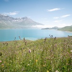
Discover a secret treasure of Haute Maurienne Vanoise. Immerse yourself in history thanks to this vestige offering a memorable view of Lake Mont Cenis. Are you ready for an experience that only ancient forts can offer?
Description
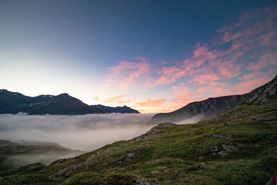
Take the 19th-century path and gradually overlook the Mont Cenis lake from its northern slope.
Perched at an altitude of 2385 m, the Italian fortification has braved the vagaries of winter for over a century on the heights of Val Cenis. The panorama is well worth the winding climb above the turquoise lake. Snow-covered late in the year, the arrival at Fort de Pattacreuse requires caution at the start of the season. Today, the estate is
still watched over by an emblematic sentinel. Whose whistling echoes in the neighboring mountain pastures? Dame marmotte watches over you all the way to the gates of the fortress.
An ancestral path now opens up before you, guiding your steps towards a forgotten past. A dry-stone wall, aged by the ages, stands beside you. Soak up the atmosphere after choosing a spot protected from falling rocks.
It will soon be time to start your descent. But you can be sure that your view of Mont Cenis will never be the same after this escape.
Additional welcome
The duration of hiking trails is calculated using reference paces: 300 m/h ascent, 500 m/h descent and 4 km/h on the flat.
As hazards may occur at any time on the routes, the GPX tracks provided are not contractual. They are given for information only. Riders use them at their own risk, depending on their level of technological proficiency and their understanding of the terrain.
-
Minimum age: 10 years
Environments
-
 Waterside
-
Lakeside or by stretch of water
-
Lake view
-
Mountain view
-
Mountain location
-
Panoramic view
-
Presence of livestock and guard dogs
Rates
Free access.
Itinerary
-
 Distance
14.5km
Distance
14.5km
-
 Route type
Round trip
Route type
Round trip
-
 Elevation gain
400m
Elevation gain
400m
-
 Negative gradient
400m
Negative gradient
400m
-
 Daily duration
04h30
Daily duration
04h30
-
 Signposted itinerary
Yes
Signposted itinerary
Yes
-
 Beaconing accuracy
Departmental signposting (PR: yellow blades)
Beaconing accuracy
Departmental signposting (PR: yellow blades)
-
 Nature of the land
Stone,
Ground,
Grit,
Not suitable for strollers
Nature of the land
Stone,
Ground,
Grit,
Not suitable for strollers
-
 Maximum altitude
2380m
Maximum altitude
2380m
Opening period
Daily from June 15 to October 31.
Subject to favorable snow and weather conditions.
Additional opening
-
Subject to favorable weather
-
Subject to snow conditions
Location
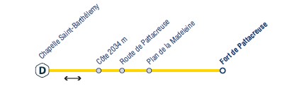
The hike starts from the St Barthélémy chapel parking lot.
I get there by car: RD1006 and after the Col du Mont-Cenis (towards Itale) take the 1st road on the right towards Col du Petit Mont-Cenis.

Animals
Pets allowed : Yes
Pets allowed with supplement : No
Pets allowed on leash only.
Guidebook with maps/step-by-step
-
To guide you in the field, consult the "step-by-step" directional diagram provided in pdf.


-
Distance
14.5km
-
Daily duration
04h30
-
Elevation gain
400m
-
Negative gradient
400m