

 Back
hike
Back
hike
Snowshoe itinerary: Val Cenis Haut trail option
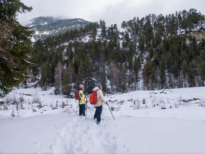
Take this downhill route and let the winter forest envelop you, among the pines and spruces, where wildlife lies hidden beneath the snow.
Description
On the way down, the trees give way to the Dent Parrachée, while the Grand Roc Noir and Pointe du Châtelard offer a panorama of silent, majestic mountains, to be savored step by step.
Additional welcome
Check the weather conditions and avalanche risk before you set out (weather services, mountain rescue services, professionals, tourist office...).
Make sure your gear and clothing are appropriate for the forecast.
Postpone your activity if the weather forecast is poor. Follow safety instructions and do not stray from marked trails in winter.
Environments
-
 Mountain view
-
Mountain location
-
Less than 10 minutes from a bus stop on foot
Rates
Free admission. The tour is free, but a valid lift pass is required to use the lifts.
Itinerary
-
 Distance
4.1km
Distance
4.1km
-
 Route type
One-way ticket
Route type
One-way ticket
-
 Elevation gain
100m
Elevation gain
100m
-
 Negative gradient
250m
Negative gradient
250m
-
 Daily duration
01h45
Daily duration
01h45
-
 Signposted itinerary
Yes
Signposted itinerary
Yes
-
 Beaconing accuracy
Marked Trail No. 4V
Beaconing accuracy
Marked Trail No. 4V
-
 Nature of the land
Non-groomed itinerary
Nature of the land
Non-groomed itinerary
-
 Maximum altitude
1680m
Maximum altitude
1680m
Opening period
Daily from December 14 to April 17.
Subject to favorable snow and weather conditions.
Additional opening
-
Subject to favorable weather
-
Subject to snow conditions
Location
As hazards may occur at any time on the routes, the GPX tracks provided are not contractual. They are provided for information only. Riders use them at their own risk, depending on their level of technological proficiency and their understanding of the terrain.

Animals
Pets allowed : No
Pets are not allowed on the lifts.
Guidebook with maps/step-by-step
-
1/ Start the hike at the top station of the Val Cenis gondola, take the snowshoe trail, and follow the open section before entering the forest.
2/ 0 h 20 - At the entrance to the forest, turn left onto the downhill path to join a wider trail at the next junction.
3/ 0 h 30 - At this intersection, turn right to reach Le Châtel, passing the Altitude 1610 crossroads and following the signs for Chapelle Saint-Étienne.
4/ 1 h 10 - From this junction, continue toward Lanslevillard - GR®5E Le Petit Bonheur - Chemin des Sarrazins and follow the wide path until you reach La Lauzière.
5/ 1 hr 35 min - At La Lauzière, head toward Lanslevillard, then turn right before the tunnel to reach the snow line and the Val Cenis Haut gondola departure station.
6/ 1 hr 45 min - Val Cenis Haut Gondola departure station.


-
Distance
4.1km
-
Daily duration
01h45
-
Elevation gain
100m
-
Negative gradient
250m