

 Back
hike
Back
hike
Snowshoeing itinerary: Forts de l'Esseillon variation

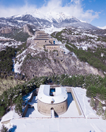
Climb the Forts de l'Esseillon, these stone giants perched high above Bramans.
Description
This loop takes you through icy streams, rushing waterfalls, and shady forest paths. As you climb, the scenery becomes increasingly rugged, until you reach the spectacular final viewpoint, offering a view of the peaks of Haute Maurienne Vanoise. A loop full of adventure, perfect for a thrill in the heart of nature.
Additional welcome
Check the weather conditions and avalanche risk before you set out (weather services, mountain rescue services, professionals, tourist office...).
Make sure your gear and clothing are appropriate for the forecast.
Postpone your activity if the weather forecast is poor. Follow safety instructions and do not stray from marked trails in winter.
Environments
-
 Mountain view
-
Mountain location
-
10 - 20 min from a train station by car
-
Less than 10 minutes from a bus stop on foot
Rates
Free access.
Itinerary
-
 Distance
9.6km
Distance
9.6km
-
 Route type
LOOP
Route type
LOOP
-
 Elevation gain
450m
Elevation gain
450m
-
 Negative gradient
450m
Negative gradient
450m
-
 Daily duration
05h00
Daily duration
05h00
-
 Signposted itinerary
Yes
Signposted itinerary
Yes
-
 Beaconing accuracy
Signposted route n°2V
Beaconing accuracy
Signposted route n°2V
-
 Nature of the land
Non-groomed itinerary
Nature of the land
Non-groomed itinerary
-
 Maximum altitude
1585m
Maximum altitude
1585m
Opening period
Daily from December 15 to April 1.
Subject to favorable snow and weather conditions.
Additional opening
-
Subject to favorable weather
-
Subject to snow conditions
Location
As hazards may occur at any time on the routes, the GPX tracks provided are not contractual. They are provided for information only. Riders use them at their own risk, depending on their level of technological proficiency and their understanding of the terrain.

Animals
Pets allowed : Yes
Pets allowed with supplement : No
Out of respect for wildlife, please keep your dog on a lead.
Guidebook with maps/step-by-step
-
1/ Start at the Bramans Town Hall, cross through the center of the village toward La Norma to reach the Croix du Mollard Chez Nous intersection.
2/ 0 h 30 - At the intersection, take the central path down to the Grotte des 14 Chapeaux. Follow this forest track until you reach the Route du Nant junction.
3/ 2 hours - At Route du Nant, take the uphill forest track and follow it for about 4 km to reach the next intersection.
4/ 3 hours 50 minutes - At the wooden signpost, take the downhill path toward Bramans to reach the Croix du Mollard Chez Nous.
5/ 4 hrs 40 mins - From the cross, take the same route as before to return to the Bramans town hall.
6/ 5 hrs - Bramans town hall.


-
Distance
9.6km
-
Daily duration
05h00
-
Elevation gain
450m
-
Negative gradient
450m