Back
hike
Back
hike
Snowshoe itinerary: Tour du Châtel

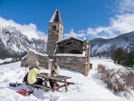
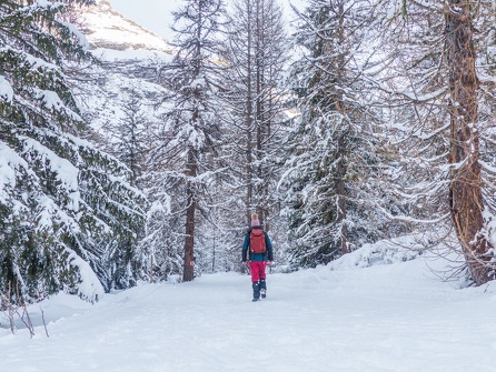
The Tour du Châtel trail winds its way through frozen streams and silent undergrowth, leading hikers toward the Sainte-Marguerite Chapel. Further on, a striking rock formation, crowned by a slender peak, stands out against the horizon.
Description
The loop ends near the Saint Clair Chapel, where the mountain seems to be holding its breath.
Additional welcome
Check the weather conditions and avalanche risk before you set out (weather services, mountain rescue services, professionals, tourist office...).
Make sure your gear and clothing are appropriate for the forecast.
Postpone your activity if the weather forecast is poor. Follow safety instructions and do not stray from marked trails in winter.
Environments
-
 Forest location
-
Mountain view
-
Mountain location
-
Isolated
-
10 - 20 min from a train station by car
-
Less than 10 minutes from a bus stop on foot
Rates
Free access.
Itinerary
-
 Distance
4.5km
Distance
4.5km
-
 Route type
LOOP
Route type
LOOP
-
 Elevation gain
120m
Elevation gain
120m
-
 Negative gradient
120m
Negative gradient
120m
-
 Daily duration
02h00
Daily duration
02h00
-
 Signposted itinerary
Yes
Signposted itinerary
Yes
-
 Beaconing accuracy
Signposted Route No. 3
Beaconing accuracy
Signposted Route No. 3
-
 Nature of the land
Non-groomed itinerary
Nature of the land
Non-groomed itinerary
-
 Maximum altitude
1300m
Maximum altitude
1300m
Opening period
Daily from December 15 to April 1.
Subject to favorable snow and weather conditions.
Additional opening
-
Subject to favorable weather
-
Subject to snow conditions
Location
As hazards may occur at any time on the routes, the GPX tracks provided are not contractual. They are provided for information only. Riders use them at their own risk, depending on their level of technological proficiency and their understanding of the terrain.

Animals
Pets allowed : Yes
Pets allowed with supplement : No
Out of respect for wildlife, please keep your dog on a lead.
Guidebook with maps/step-by-step
-
1/ From Place Saint Clair, walk between the houses along the snow-covered meadows to reach Plan de l'Église.
2/ 0 h 10 - At the intersection with Plan de l'Église, take the left fork and follow the path along the edge of the forest to Hauts du Verney.
3/ 0 h 35 - Follow the signs for Le Châtel to the right, then continue on the wide track to Le Châtel.
4/ 1 h 10 - At Le Châtel, head back toward Bramans, crossing Les Hauts du Verney again, until you reach the Les Hauts du Verney 1240 landmark.
5/ 1 hr 40 min - At this intersection, follow the Bramans route back to Place Saint Clair.
3/ 2 hrs - Place Saint Clair.


-
Distance
4.5km
-
Daily duration
02h00
-
Elevation gain
120m
-
Negative gradient
120m