Fort du Mont-Froid hiking trail
The tone is set as soon as you leave Col du Mont Cenis. You are about to sample the joys of vast high-altitude landscapes! Explore the wilderness between endless alpine meadows and rocky outcrops as you flirt with the high mountains.
Description
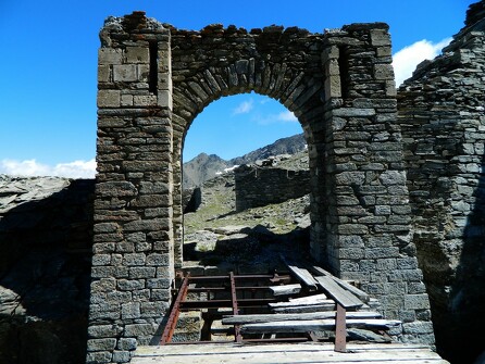
There's a short warm-up through the Tarines alpine pasture. In high-altitude grasslands, mischievous marmots play hide-and-seek and whistle at your approach. Turn into the tranquility of Grand Plan to prolong your journey. An even rockier landscape opens out ahead of you. Make your way through the dolines (sinkholes) and curious depressions that herald the Col de Sollières. Many switchbacks later, you'll conquer the final ridge and reach its summits. The chamois are watching you, clearly intrigued. The old barracks bear witness to the site's military history. Here, among the peaks, exhilaration takes hold of you as you follow a path that seems to connect heaven and earth. "Queen Meije," the Aiguilles d'Arves, and Barre des Écrins lie in the distance yet seem so close. Take a deep breath as you face the Vanoise Glaciers and the Grande Casse. Upon arrival at the Fort, magical panoramic views and a touch of heritage await you: a fitting reward for your ascent to 2,822 metres of altitude.
Additional welcome
The duration of hiking trails is calculated using reference paces: 300 m/h ascent, 500 m/h descent and 4 km/h on the flat.
As hazards may occur at any time on the routes, the GPX tracks provided are not contractual. They are given for information only. Riders use them at their own risk, depending on their level of technological proficiency and their understanding of the terrain.
-
Minimum age: 12
Environments
- Lake view
- Mountain view
- Mountain location
- Presence of livestock and guard dogs
Rates
Free access.
Itinerary
-
 Distance
12km
Distance
12km
-
 Route type
Round trip
Route type
Round trip
-
 Elevation gain
720m
Elevation gain
720m
-
 Negative gradient
720m
Negative gradient
720m
-
 Daily duration
05h00
Daily duration
05h00
-
 Signposted itinerary
Yes
Signposted itinerary
Yes
-
 Beaconing accuracy
Departmental markings (PR: yellow blades)
Beaconing accuracy
Departmental markings (PR: yellow blades)
-
 Nature of the land
Stone,
Ground,
Grit,
Not suitable for strollers
Nature of the land
Stone,
Ground,
Grit,
Not suitable for strollers
-
 Maximum altitude
2822m
Maximum altitude
2822m
Opening period
From 01/07 to 01/10.
Subject to favorable snow and weather conditions.
Additional opening
-
Subject to favorable weather
-
Subject to snow conditions
Location
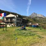
Getting there by car: from the Col du Mont-Cenis, take the tarmac road 200m down towards the Col du Petit Mont-Cenis. Park in the Petit Mont-Cenis refuge parking lot.
Documents

Animals
Pets allowed : Yes
Pets allowed with supplement : No
Pets allowed on leash only.
Guidebook with maps/step-by-step
-
To guide you in the field, consult the "step-by-step" directional diagram provided in pdf.


-
Distance
12km
-
Daily duration
05h00
-
Elevation gain
720m
-
Negative gradient
720m